Ijjay Bantay Katayagan
Mt. Katayagan
Agoo,
La Union
My
hometown, Agoo, is mostly flat, except for the low mountain protruding to the
east. Since childhood, I am always looking forward to climb this mountain named
Mt. Katayagan. But I never managed to get up there, until recently.
Katayagan
originated from the root word "Tayag" which means tall in Ilokano.
When we add the affixes "Ka" and "-an', the new word would mean
tallest. Therefore, in Ilokano dialect, Mt. Katayagan translates to Mt.
Tallest. And this is true in the case of my hometown Agoo, because standing at ~250masl, Mt. Katayagan is the highest peak.
With
my recent interest in hiking, I decided to climb Mt. Katayagan once and for
all. It would be a dishonour to the looming peak in my backyard if I get to
enjoy and appreciate other mountains without paying homage to my own.
So,
before flying back to my hometown for my two-week vacation in September, I contacted
friends who could lead me to a guide. Most of them directed me to the
mountaineering group in Agoo called Katayagan Mountaineering Team aka KAMOTE.
Through a friend, I was able to schedule a sunset hike with the group.
Aside
from Kamote, my elementary classmate also accompanied me. He is a local of
Brgy. Sta Fe (our exit point) and basically knows the trail to the peak via
Sta. Fe.
Come
hike day, we assembled at Grotto past 3pm. Our goal is to witness the sunset at
the summit. Estimating a two-hour trek to the top, we would be on time for the
sundown.
The
first part of the trail is the Grotto stairs. At the top, a dirt track leads into
the base of the mountain. This is the easy stage of the hike with gentle
ascending slopes. It is also notable
that charcoal making (burning of dried coconut shells in a small pit) was observed on the
path.
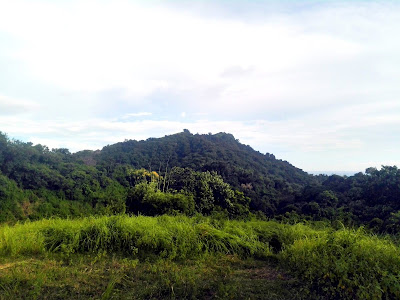
At the base of the mountain, we rested for a bit, and took photos of Mt. Katayagan. In an hour or so, we would already be on the top.
 |
| Mt. Katayagan photographed from the base. |
 | |
| Thumbs up because I just got out from the weeds. |
 |
| The raincoat that saved my arms from further scratches. |
 |
| The mountain resort of our town mayor. |
 |
| Nearly to the top. |
 | |
| Catching sunset from Mt. Katayagan's peak. |
 | |
| Katayagan's cross at the peak. |
 |
| With Agoo Mountaineer's KaMoTe. |
It
was already dark when we descended and we have to use flashlights. At the sight
of the first sari-sari store, we bought cold sodas. My elementary friend from
Sta. Fe volunteered to drive us back to the center of Agoo where we had our
socials. It was my first climb with the group, and over a couple of beers, we
shared our passion and dream hikes. Most definitely I would climb with them
again in the future.
Mt. Katayagan is a very special hike and really dear to my heart. It is home, it is where my roots are planted. It is also the fulfilment of a little girl's
adventure goals, a tick to my younger self's bucket list.
I
would definitely bring Tala to Mt. Katayagan as soon as we get her hiking
gears. I have to start her young in order for her to appreciate nature and adventure. It is an easy hike, and I know for sure, she can do it.
Climb
Date: September 17, 2017
Summit
Elevation: ~250mASL
Difficulty
Rating: 2/9
Jump-off
Point: Grotto
Exit
Point: Sta Fe
Days
Required/Hours to Summit: 0.5 day/2 hours
Features:
Tall weeds with razor sharp edges
Geology:
Localised volcanic flows
Guide:
Agoo Katayagan Mountaineering and Outdoor Team (KAMOTE)
Contact
Person: Ron Junio, Jen Di, Efraim Niñalga


love the texts! i never imagined Katayagan will be vividly described like this!
ReplyDeleteOmg, ngayon ko lang nabasa to Sir Mito. Thank you for the kind words.
DeleteIt represented home.. Thanks for sharing��
ReplyDeleteThank you Sir Rexford for appreciating.
DeleteGood readings
ReplyDeleteThank you!
DeleteJust got home from mt. katayagan. i had so much fun.
ReplyDelete